
Mapping Flint: Flint River Watersheds
Cartographer Alex B. Hill shares information about Flint’s watersheds and the impressive work underway.
This is part of the Mapping Flint series from cartographer Alex B. Hill, a self-described “data nerd and anthropologist” who combines mapping, data, and analytics with storytelling and human experience. He is the founder of DETROITography and author of “Detroit in 50 Maps and Great Lakes in 50 Maps.
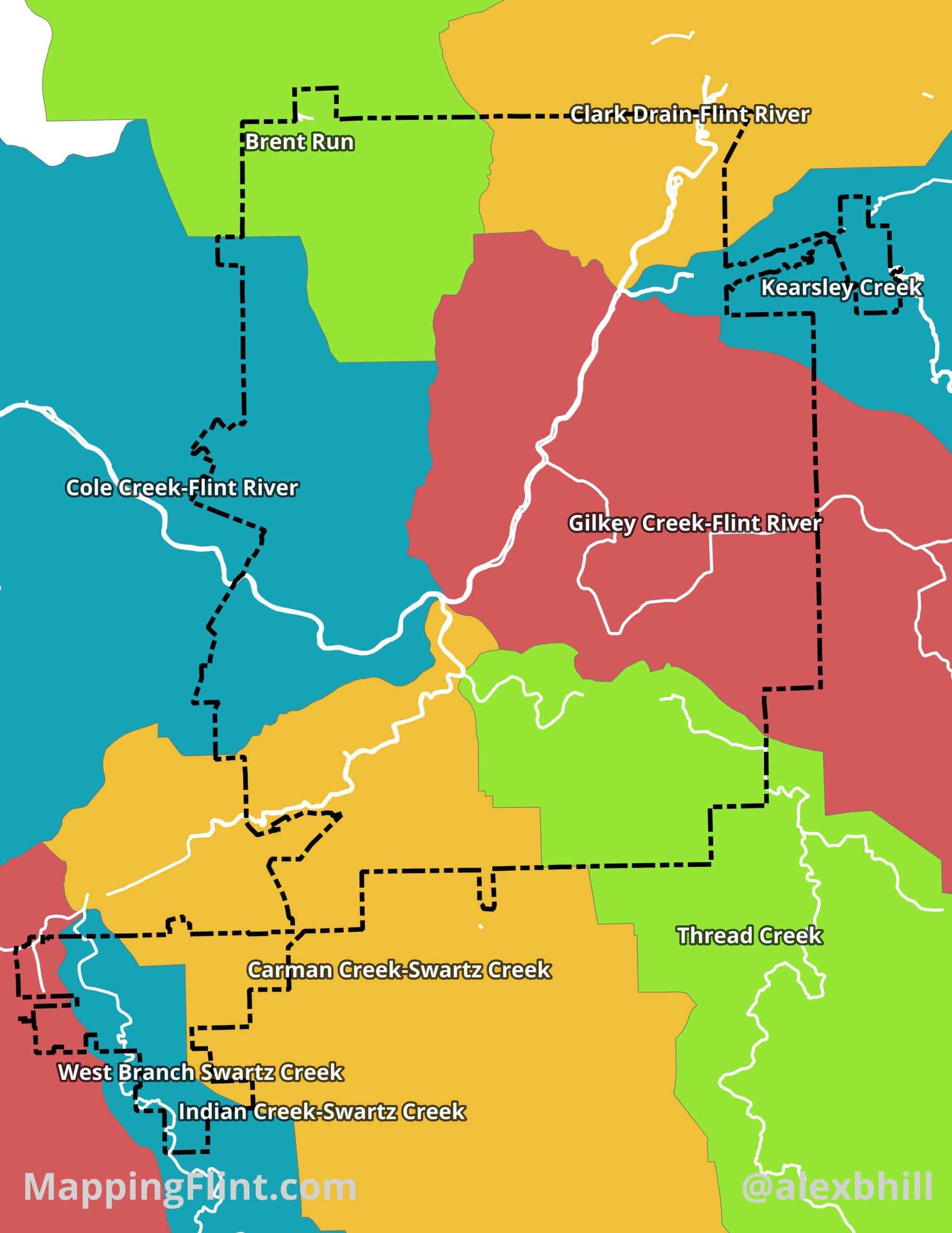
FLINT, Michigan — The Flint River Watershed is a vital, 1,363-square-mile drainage basin across seven southeastern Michigan counties, ultimately feeding into the Saginaw Bay and Lake Huron. Originating in Columbiaville, the river flows northwest through diverse landscapes, including agriculture, forests, and the urban center of Flint.
Historically central to regional development and mill power, the watershed now faces significant environmental stress from industrialization and urban runoff. Persistent issues such as nutrient runoff, bacterial contamination, and legacy pollutants threaten aquatic life and recreational use, making cleanup essential for the region’s ecological and economic health.
Numerous organizations are actively dedicated to the conservation and restoration of the Flint River Watershed. Leading the local charge is the Flint River Watershed Coalition (FRWC), a non-profit group that focuses on monitoring water quality, restoring natural habitats, and educating the public. The Michigan Department of Environment, Great Lakes, and Energy (EGLE) provides regulatory oversight, funding, and technical assistance. This multi-faceted, collaborative approach is essential for addressing contamination.
Larger regional and national organizations, such as the Saginaw Bay Watershed Initiative Network (WIN), support the health of the Flint River by addressing broader ecosystem connections and non-point source pollution. Various environmental groups and universities also contribute by conducting research on pollution sources, developing innovative restoration techniques, and advocating for stronger environmental policies.
This network of dedicated organizations is crucial to the ongoing work of protecting, restoring, and ensuring the long-term vitality of the Flint River and its surrounding lands.
Author

Related Articles
Mapping Flint: Roadways
Mapping Flint: Roadways explores how the city’s road names reveal its history, growth, and geography.
Mapping Flint: Flint Vacant Land
Alex B. Hill, dives into Flint’s vacant land.
Mapping Flint: Understanding Flint Geography
The “Mapping Flint” series from cartographer Alex B. Hill, a self-described “data nerd and anthropologist,” arrives at Flintside.

