
Mapping Flint: Roadways
Mapping Flint: Roadways explores how the city’s road names reveal its history, growth, and geography.
Editor’s Note: This is part of the Mapping Flint series from cartographer Alex B. Hill, a self-described “data nerd and anthropologist” who combines mapping, data, and analytics with storytelling and human experience. He is the founder of DETROITography and author of “Detroit in 50 Maps and Great Lakes in 50 Maps.
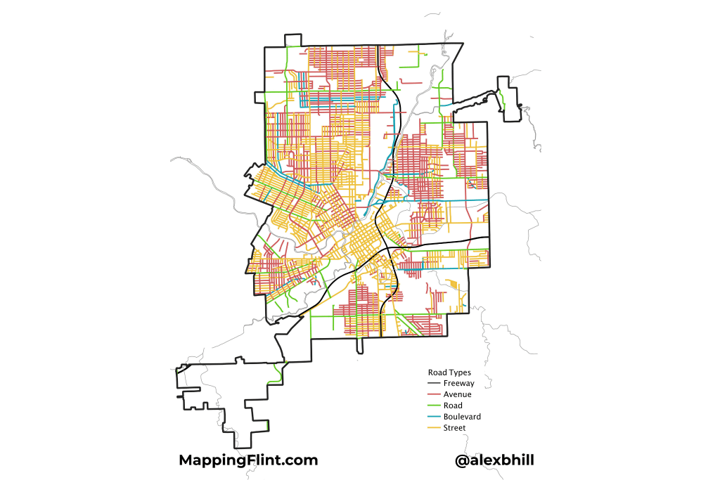
FLINT, Michigan — Flint’s roadways follow a merged historical pattern and urban grid layout. The downtown area features a high-density, traditional grid network near the Flint River and surrounding areas like Saginaw Street and Beach Street.
Much like Detroit, early roadways were defined around the river direction before being planned by cardinal directions. Key north-south routes include Saginaw Street, Chavez Drive, and Crapo Street. Major east-west routes include Third Street, Kearsley Street, and Robert T Longway Boulevard.
I first saw this roadway name-mapping idea in Bill Rankin’s work in Vancouver, and then Derek Watkins applied a similar approach to the Portland–Seattle area. I was finally given my last push and decided to create this map after following Bostonography — which mapped out the roadway naming in the City of Boston. This type of map has now become a commonly created map of interest for any city. There are tiny details that reveal interesting bits of history and take you down new paths.
The patterns of roadway naming show the growth and change of Flint over the years. There are not many Boulevards which show how that road type was reserved for important places. The “Road” naming itself didn’t become more common until after U.S. control of the Michigan Territory, when standardized land surveying and urban planning instituted a recognizable grid system.
It appears that “Street” was the top choice of early Flint development, while “Avenues” became popular later. The Avenue groupings pop up on the edges of the city. Notably, Flint’s hydrology: rivers and creeks heavily influenced the road layout, creating areas of less roadway density.
Author

Related Articles
Mapping Flint: Out-of-State Taxpayers
Mapping Flint’s property data reveals growing out-of-state ownership, LLCs, and investor interest.
Mapping Flint: Flint River Watersheds
Cartographer Alex B. Hill shares information about Flint’s watersheds and the impressive work underway.
Mapping Flint: Flint Vacant Land
Alex B. Hill, dives into Flint’s vacant land.
